Topics Bachelor's theses in Earth and Climate Sciences
Bachelor's theses topics on research group websites
Bachelor's thesis topics in SiROP
Many research groups in the Department of Earth and Planetary Sciences advertise Bachelor's theses through the external page student research project website SiROP.
The feed below shows a selection of currently available projects.
AI-based object detection in debris flows
Debris flows are extremely rapid, flow-like landslides composed of boulders, woody debris as well as a viscous slurry. They are an important geomorphic process which transport sediment to the river system as well as a significant hazard to infrastructure and people. For the process characterization, hazard assessment and early warning, debris-flow monitoring is important but challenged by the harsh conditions of alpine environment in which they occur. A novel monitoring technique uses cameras and lidars to collect high-resolution information of moving debris flows. To better understand why debris flows are so mobile and destructive, we are interested in studying individual objects within the flow, such as boulders. However, because of the large amounts of data tracking individual boulders manually is unsatisfacory. Recent AI-based object detection algorithms offer an automated alternative. This project will analyze data from a debris-flow monitoring station in Öschibach (Fig. 1), where many debris flows occurred in 2024 as a result of the active Spitze Stei landslide and abundant rainfall. As a consequence, a bridge was destroyed and the ski slope will not open next season. The student will manually label boulders on camera images, which will be used to train an AI-based object detection algorithm (Fig. 2). This will enable to automatically detect many more boulders than a human could ever do in reasonable time. By projecting the detections on to the LiDAR point clouds, we obtain 3D informtaion of individual boulders (Aaron et al., 2023). The new data set will be used to analyze the veocities and grain sizes of debris-flow objects and will help to answer questions such as how debris flows maintain their bouldery and destructive front.
Labels
Bachelor Thesis
More information
Open this project... call_made
Published since: 2024-12-10 , Earliest start: 2025-03-01 , Latest end: 2025-06-30
Organization Engineering Geology
Hosts Hirschberg Jacob
Topics Earth Sciences
Analyzing Feature Velocities in Debris Flows using 3D Laser Scanners Illgraben, Switzerland
Debris flows are extremely rapid, flow-like landslides composed of fine and coarser-grained components, boulders, woody debris and water. They are characterized by large impact forces as well as long runout distances and are one of the most dangerous types of mass movements in mountainous regions. Managing the risk posed by this type of landslide is particularly important for alpine countries like Switzerland, where debris flows have caused major damage and led to numerous fatalities in the past. More detailed field-scale measurements of natural debris flows are required to better understand the fundamental mechanisms governing debris-flow motion and, ultimately, to reduce the associated risks in the future. However, such measurements of moving debris flows – and in particular of their velocity – are generally rare. Investigating the distribution of velocities within a debris flow is crucial as it controls the discharge and thus the volume of an event. These are both important parameters in practical debris-flow hazard assessment. The measurements of debris-flow velocity performed in the proposed project are based on high-resolution, highfrequency 3D point clouds from laser scanners (Ouster LiDAR sensors). These sensors were originally developed for driverless cars and have been installed in the Illgraben (Valais, Switzerland), one of the most active debris-flow catchements in the Alps, for debris-flow monitoring in 2021 (Figure 1). The student working on this project will analyze point-cloud data from one or multiple debris flows recorded by a laser scanner at the Illgraben to investigate the velocity of these flows. In particular, the student will use Matlab to track features visible at the surface of the flow (Figure 2) and to determine the velocities of these objects. For this purpose, point-cloud data of recent debrisflow events will be provided along with existing Matlab scripts, which can be modified and improved by the student. The findings of this Bachelor’s project will have important implicatinos for the understanding of debris-flow dynamics as well as for the measurement of hazard-related parameters such as discharge and volume. No special skills are required, however an interest in natural hazards is considered an asset and some programming experience (Matlab or Python) will be helpful. Furthermore, the student will likely have the opportunity to visit the Illgraben (Figure 1) in order to understand the sensor array and to potentially help with sensor calibration works.
Labels
Bachelor Thesis
More information
Open this project... call_made
Published since: 2024-12-10 , Earliest start: 2025-03-01 , Latest end: 2025-06-30
Organization Engineering Geology
Hosts Aaron Jordan
Topics Earth Sciences
Fibre-optics-based deformation and temperature sensing during a fault reactivation experiment
In April and August 2024, two long-term hydraulic stimulation were performed at the Bedretto underground laboratory to investigate the deformatiln field and rupture processes of fluid induced earthquakes. Fibre-optic cables and sensors, that are part of a multi-sensor monitoring system installed in various borehole around the main injection boreholes, recorded deformation and temperature changes during these experiments. The different fibre-optic systems include FBG sensors that record deformation and temperature at distinct locations, distributed strain sensing (DSS) cables that recorded distributed strain, distributed temperature sensing (DTS) cables that record temperature, as well as a distributed acoustic sensing (DAS) system that recorded strain and strain rate at high frequencies along boreholes. Both deformation as well as temperature disturbances during the experiments indicate active flow in fractures. The goal of this project is to carefully analyse these disturbances in connection with fractures mapped in the boreholes. Based on this, the fracture network that was pressurized and that was hydraulically active can be reconstructed and compared to the seismicity cloud produced through stimulation. However, in a first step, the different systems need to be compared; for instance temperature recordings from FBG and DTS or deformation recordings from FBG and DAS have to be checked for consistency. The student working on this project would thus not only uncover the reactivated fracture network during a hydraulic stimulation experiment based on different monitoring systems, but also learn the functionality, accuracy and comparability of the different fibre-optics-based systems.
Labels
Bachelor Thesis
More information
Open this project... call_made
Published since: 2024-12-10 , Earliest start: 2025-03-01 , Latest end: 2025-06-30
Organization Engineering Geology
Hosts Gischig Valentin
Topics Earth Sciences
Quantification of landslide sediment angularity using machine-learning assisted image segmentation
For engineering geological purposes, one often needs to characterize and classify a sediment or soil material, which requires the assessment of a set of parameters like grain size, grain shape, angularity. However, obtaining reliable and representative data for these parameters can be challenging, especially for large areas or complex terrains. Traditional methods of mapping and classification often require manual labor and field work, which can be time-consuming, costly, and – particularly in the absence of laboratory testing – be prone to human error or bias. Moreover, these methods may not capture the spatial variability and heterogeneity of the sediment or soil properties across the area of interest. In order to automate the process of sediment mapping we use high resolution optical images. These images can then be processed using a machine-learning assisted image segmentation technique, allowing to extract the outlines of individual sediment clasts for the entire area (Fig. 1 see attachment). Based on these outlines, we can then compute various parameters for each clast, such as its size, shape, angularity, and orientation. Furhtermore, we can analyze the distribution and statistics of these parameters for the whole area, and use them to identify and describe the sediment characteristics for different sub-regions. In this project, we aim to automate the derivation of clast angularity. While we can use the same machine learning assisted algorithm to determine the clast outline, the calculation of the angularity will be very sensitive to the outline being correct and particularily when clasts overlap each other (Fig. 2). To extract only those parts of the visible clast outline, which belong to the original clast and not a clast overlapping it, we plan to use 3D point clouds derived from lidar scans and/or photogrammetry to provide us with information regarding the superposition of individual clasts. Based on this 3D spatial information the student will derive an automated workflow (in ArcGIS pro, QGIS, or python) to extract the clast outline and calculate it’s angularity. To derive the clast outlines, the student will apply an existing python script and workflow to this data set and extract grain size distributions and potentially other parameters. Prior knowledge of python is not required and the student would not need to write much new own code, but an interest in coding is advantageous. Furthermore, a GIS software (QGIS or ArcGIS Pro) and potentially a photogrammetry software for drone footage analysis will be used. Depending on the exact timing of the project and the weather conditions at that moment a few days of field work will be planned to acquire additional drone footage of the Insel deposit in Brienz/Brinzauls GR (Fig. 3).
Labels
Bachelor Thesis
More information
Open this project... call_made
Published since: 2024-12-10 , Earliest start: 2025-03-01 , Latest end: 2025-06-30
Organization Engineering Geology
Hosts de Palézieux Larissa, Dr
Topics Earth Sciences
Thermo-mechanical response of Rotondo Granite with different cooling treatments
Geothermal energy is playing a pivotal role in the transition of the Swiss energy sector from reliance on fossil fuels and nuclear power to sustainable sources. Aligning with this, the Bedretto Underground Laboratory serves as a testbed for hydraulic stimulation experiments that are essential for enhancing the permeability of Enhanced Geothermal Systems (EGS) (Figure 1a). In addition to hydraulic stimulations, the temperature discrepancy between the injection fluid and the hot reservoir rock can induce thermal fractures due to rapid cooling near the injection wells and slower cooling in the more distant field. It is vital to quantify the deterioration of the reservoir rock mechanical strength caused by thermal cracking to ensure the structural integrity of injection and production wells in EGS. This study aims to investigate the mechanical response of Rotondo Granite, sourced from the Bedretto lab. Brazilian Disk Tensile Strength (BTS) tests will be performed on specimens treated under various temperature and cooling conditions at the Rock Mechanics and Physics Lab (RPM Lab) (Figure 1b). Heat treatments will include increasing the temperature from 25 °C to 800 °C using a high temperature furnace, followed by both rapid and slow cooling. The results of this study will provide a comprehensive data set describing the mechanical strength degradation of Rotondo Granite following heating and cooling treatments. The student will learn how to prepare rock specimens, conduct BTS tests, and interpret the tensile strength of the reservoir rock according to ISRM standards. Necessary training will be provided on preparing the testing specimens, setting up testing equipment, data acquisition systems and analyzing the test results.
Labels
Bachelor Thesis
More information
Open this project... call_made
Published since: 2024-12-10 , Earliest start: 2025-03-01 , Latest end: 2025-06-30
Organization Engineering Geology
Hosts Vidanage Radhika
Topics Earth Sciences
Winter snow accumulation on Rhonegletscher
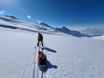
Snow accumulation is a critical parameter for glacier mass balance investigations. Conventional measurements include snow depth probings while ground penetrating radar (GPR) has been successfully applied for continuous measurements of the snow cover thickness.
Keywords
Glaciology, Geophysics, GPR, Glacier mass balance
Labels
Semester Project , Bachelor Thesis
Description
Goal
Contact Details
More information
Open this project... call_made
Published since: 2024-09-20 , Earliest start: 2025-01-15 , Latest end: 2025-09-30
Organization Glaciology (Prof. Farinotti)
Hosts Bauder Andreas
Topics Earth Sciences